Birds in This Story
Wood Stork
Latin: Mycteria americana

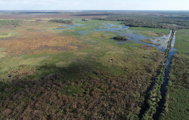
Corkscrew Swamp Sanctuary hosted the Corkscrew Watershed Science Forum on Friday, May 12. This annual event, started by Audubon staff in 2015, encourages scientists, engineers, land stewards, and others working in the Corkscrew Regional Ecosystem Watershed (CREW) to share their work with colleagues, policy staff, decision makers, and volunteers. The CREW Land & Water Trust was established in 1989 as a nonprofit organization to coordinate the land acquisition, land management, and public use of the 60,000-acre Corkscrew Regional Ecosystem Watershed. The watershed spans portions of Lee and Collier County and includes Corkscrew Marsh, Bird Rookery Swamp, Flint Pen Strand, Camp Keais Strand, and Corkscrew Swamp Sanctuary.
Corkscrew Watershed Science Forum
More than 70 environmental professionals attended the 2023 forum, the first since 2019. Along with scientific presentations, the event encouraged participants to share resources and discuss opportunities for future collaboration across the watershed. Topics included nuisance shrub management, mammal monitoring, using drones to answer ecological questions, and more.
Water Restoration: A Forum Focus
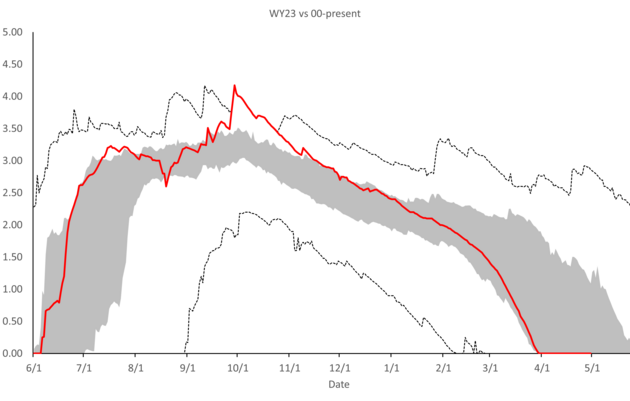
The event was kicked off with presentations that provided an update on efforts to restore regional water levels. Prior to the mid-2000s, local wetlands held water throughout the entire winter “dry” season in most years, but development downstream of CREW has led to too much water flowing out of the landscape, threatening wildlife habitat and making the region more vulnerable to catastrophic wildfire.
Addressing this problem began with a modeling study, carried out by Water Science Associates and funded by Audubon and the South Florida Water Management District. Following the completion of the model in 2021, Audubon and the District have continued to increase water level monitoring and to collect additional data that will ultimately guide restoration efforts.
Brad Jackson, Senior Engineer with the District, outlined the history of this collaborative effort, including progress on a new modelling tool that will be completed later this year. This tool will allow water managers to develop a comprehensive plan to balance competing needs for water, and ultimately to restore freshwater flows to Corkscrew Swamp Sanctuary and Bird Rookery Swamp.
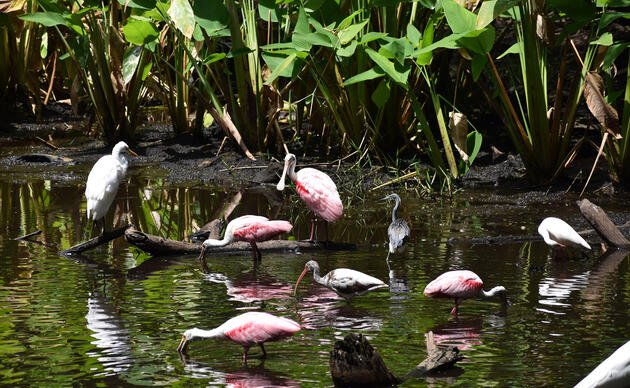
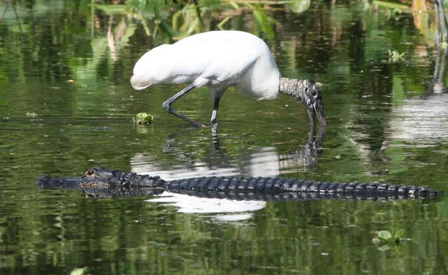
Wood Storks in the Western Everglades
A presentation by event organizer Shawn Clem, PhD, Corkscrew Swamp Sanctuary’s Director of Research and Interim Conservation Director, illustrated how Wood Stork's use of this habitat has declined over time. Historically, tens of thousands of Wood Storks nested in Southwest Florida, arriving in October to begin the nesting season. Moving west to east across the landscape as water levels dropped, Wood Storks began their nesting in our region because the shallow wetlands in this area were more accessible in the fall months when the majority of the Everglades system was still under water. As dry season sets in, they traveled farther east and down into Everglades National Park.
Over the past fifty years, however, tens of thousands of nests in Southwest Florida decreased to a few hundred birds. Storks feed on small fish that reproduce in shallow, grassy wetlands and need deeper water to survive the dry season. Availability of these fish drives Wood Stork nesting success. As “no nesting” years became more common at the Sanctuary, colonies at Lenore Island (in the Caloosahatchee River) and near Big Cypress Preserve began to form. While the USFWS recovery target for South Florida is 2,500 pairs, we are not there yet. Birds have shifted north outside their historic range and are increasingly nesting in every location except the Everglades. However, we do not know if these new nesting outposts will survive long-term, and it is risky to rely on them for the health of the entire Wood Stork population. Read more here.
Restoration Update
Senior Resource Manager Allyson Webb presented an update on the Marsh and Prairie Restoration, focusing on the removal of Carolina willow, a native-nuisance, woody shrub. Since 2008, the team has removed more than 1,100 acres of shrubs, with up to 1,000 acres of willow remaining.
The restoration entails a three-step process, including mulching the shrubs, treating regrowth, and introducing prescribed fire. The restoration has completely restored 115 of the first 1,000 acres. With the recent addition of a new airboat to the fleet, the restoration team looks forward to having the ability to continue the prescribed fire season into the summer.
Webb noted that this isn’t a one-size-fits-all approach, however, as some remaining areas may require different methods to protect sensitive peat soils and the nearby old-growth cypress forest.
Managing Carolina willow in grass-dominated wetlands is critical because mature willow doesn’t support fire, reduces wildlife habitat, and absorbs precious water.

Sanctuary Monitoring Programs
Audubon staff are using a variety of methods to document changes in plant and animal communities to inform best practices for and evaluate outcomes of, the restoration. Staff is monitoring plants, soil, wading bird foraging, aquatic wildlife, and mammal habitat use.
Restoration technician Jacob Zetzer has been using a UAV (unmanned aerial vehicle, also known as a drone) to photograph vegetation communities pre- and post-restoration. Monitoring vegetation shows changes in plant communities on a species level and enables the team to identify the plants necessary to reintroduce fire to the units. Monitoring the regrowth of woody shrubs in the restoration area is especially important because Carolina willow always requires follow-up treatment, and the drone enables us to be more precise in our treatments - which saves time and money.
In 2022, Zetzer began using drones to monitor how birds are using the restored area. After much trial and error, he figured out the exact height, angle, and speed he needed for the drone to provide the best view for identification with minimal disturbance to the birds. The surveys showed a variety of waterbirds using last year’s mulched areas—a good sign.
Corkscrew Swamp Sanctuary staff conducted a mammal monitoring study from 2013 to 2019 using camera traps to establish baseline data for future reference. The cameras collected more than 930,000 photos that provided information on the relative abundance of 18 species and provided data on their habitat preferences over time.

Establishing this baseline description of mammal communities will guide habitat stewardship activities, such as restoration and prescribed fire. Another benefit? Knowing if and how Burmese pythons are impacting the Sanctuary. Because mammals make up the majority of the Burmese python’s diet, these data are useful for understanding mammal population dynamics without heavy impact from pythons, which have been found nearby but not in the sanctuary, yet. These data will serve as a useful reference for many locations that do not have pre-python data.
Related Presentations
The health of wetlands in the region can be quantified and enhanced by many methods. One study by FWC is looking into the disease, feline leukomyelopathy (FLM), which began affecting Florida bobcats of all ages and young Florida panthers in 2017. FWC has trapped bobcats and put collars on females to help find and study kittens in the den, as well as any bobcats and panthers that they release in affected areas.
Two presentations discussed the restoration progress at nearby Picayune Strand State Forest, which is a component of the Comprehensive Everglades Restoration Plan begun in 2000. The first study looked at which plants have regrown in areas abandoned by development in the 1970s. The cypress forest is not coming back quickly – trees start to grow but don’t establish easily. While established cypress forests typically exclude sabal palms, in this location where water levels are still impacted, sabal palms took over. Data from this study can inform future restorations about how native plants respond to restoration and regenerate inside a construction footprint.
Even though much of the Picayune Strand restoration work is complete, the disturbance is still ongoing, and more recovery time is needed to evaluate the results. Florida Gulf Coast University (FGCU) student Tiffany Gaglia’s thesis explained that the presence or absence of certain species of insects and other animals without backbones corresponds with water levels as good indicators of restoration progress.
In a study conducted by FGCU faculty monitoring Eastern diamondback rattlesnakes, transmitters implanted in the snakes are showing how snakes are impacted by storms, climate change, and parasites, like snake lungworm which was introduced by Burmese pythons and expanding its range. Another study by FGCU faculty looked into the spread of Endocrine Disruptor Chemicals (EDCs), which are chemicals found in everyday products that can mimic or interfere with hormones. These chemicals are found in septic tanks and stormwater runoff, as well as in community ponds, natural areas, and the Gulf of Mexico.
In the final presentation, we learned that change events like hurricanes are great opportunities for science and that GIS (Geographic Information Systems) technology is a great tool for collecting baseline data in advance of any storm. The GIS team at Naples Botanical Garden used GIS to identify areas of vulnerability while providing a mechanism to centralize emergency response and future management activities. Sharing this data, such as at events like this one, can improve storm resilience for the entire community.
Why this Matters
An underlying theme throughout the event was the need to conserve and protect the wetland habitats that remain in Southwest Florida, particularly shallow wetlands. We need healthy wetlands to protect water quality, recharge aquifers, reduce the risk of catastrophic wildfires, and hold water during big rainfall events. Luckily, the synergies created during the event will continue to grow; ultimately these partnerships will make our region more resilient to climate change and more.